Home | Mini UAC Series | MiniUAC-4001
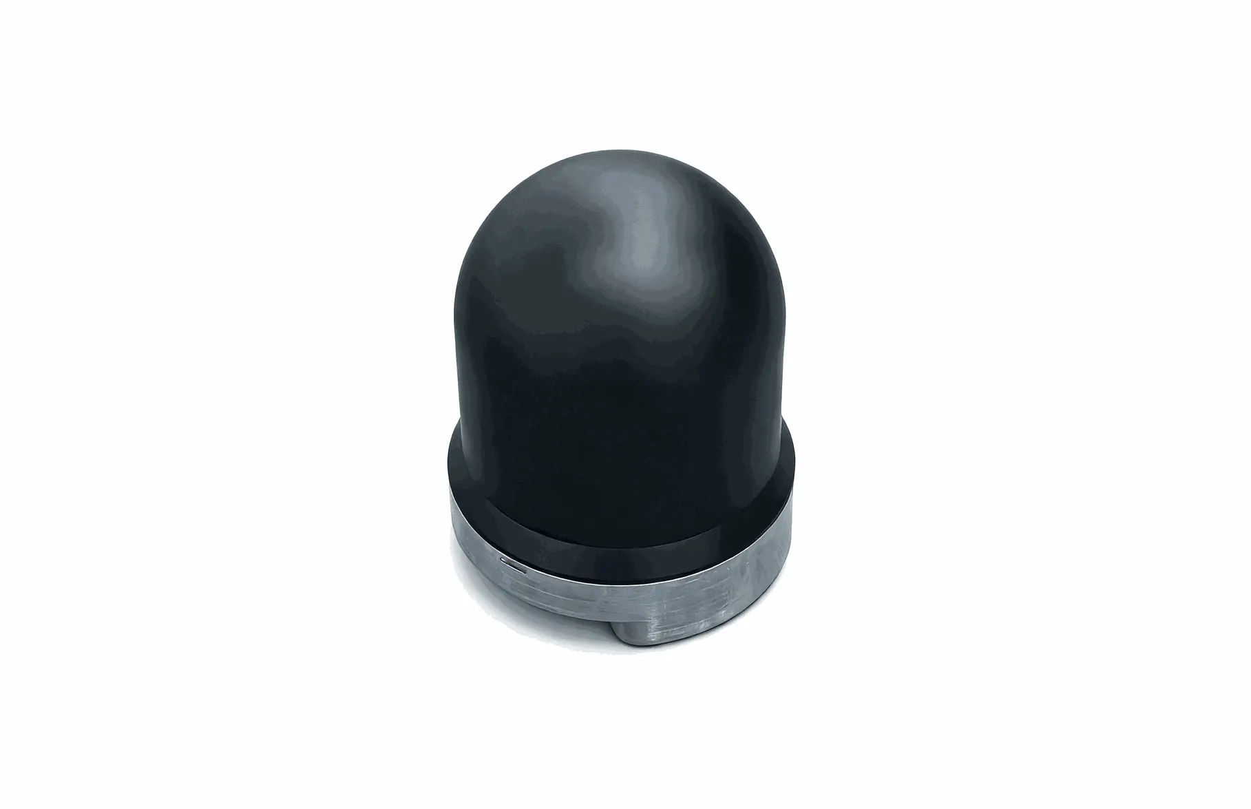
MiniUAC-4001 Panoramic 3D Sonar
High-Resolution Mechanical Scanning Sonar: Full-Coverage Scenario & Cost-Efficient Design
The MiniUAC-4001 3D sonar is a full-scene, high-resolution, and cost-effective scanning sonar.
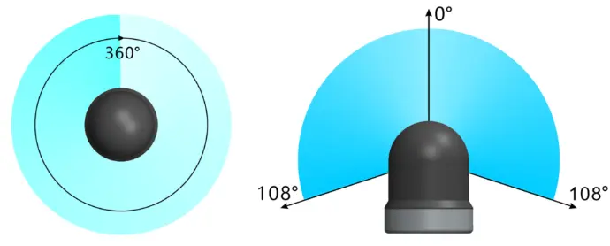
By means of mechanical scanning, the system enables full-scene 3D model reconstruction with 360° horizontal and 210° vertical coverage. It provides ultra-high-resolution point-cloud mapping for fixed underwater targets such as seabed terrain, marine engineering structures, offshore wind turbine foundations, and bridge piers.
Overview
MiniUAC-4001 Imaging Sonar
Key Features:
- Full-scene 3D scanning, with a single scan covering 360° × 216°
- Multiple viewing modes, including top view, first-person view (FPV), and 3D point-cloud visualization
- 2D and 2.5D display modes, enabling 2D intensity images at different vertical angles and providing a forward-looking sonar-like display
- Point-cloud visualization, filtering, coloring, and export functions
- Compact size, low power consumption, and significantly lower cost compared to real-time 3D sonars
Product Description
The MiniUAC-4001 3D scanning sonar is a full-scene 3D imaging sonar primarily designed for scanning the three-dimensional contours of fixed objects in water. It features low cost, compact size, light weight, and low power consumption. Thanks to its sealed oil-filled design with no external rotating parts, the sonar effectively avoids bearing blockage caused by sediment and eliminates the risk of entanglement by seaweed or fishing lines.
The MiniUAC-4001 operates using a single-beam dual-axis scanning mechanism. Echoes acquired at each scanning position are used to construct both intensity images and point-cloud data of the scene. The θ-axis provides 360° omnidirectional scanning, while the φ-axis covers a range of 0° to 108°, enabling coverage of the entire water column. Scanning range, speed, and resolution are all software-configurable. The software simultaneously displays 2D grayscale images and 3D point-cloud views, and also supports layered visualization.
The MiniUAC-4001 sonar is available in 750 kHz, 1 MHz, and 1.2 MHz frequency options. Other frequencies can be customized upon request.
The standard model supports a maximum operating depth of 300 m. For deeper applications, please contact us.
Specifications
Applications
- Underwater 3D Sonar Mapping
High-resolution 3D sonar scanning and point-cloud reconstruction for seabed terrain and fixed underwater objects using panoramic 360° mechanical scanning.
- Marine Engineering Structure Inspection
Detailed 3D inspection of bridge piers, quay walls, caissons, and other marine engineering structures for shape analysis and condition assessment.
- Offshore Wind Foundation Survey
Precise three-dimensional imaging and measurement of offshore wind turbine foundations and subsea support structures. - ROV-Based Underwater 3D Imaging
Compact, low-power 3D sonar for integration with ROVs and tripod platforms, enabling cost-effective underwater inspection and mapping.
- Underwater Point-Cloud Data Acquisition
Generation, visualization, and export of high-density underwater point-cloud data for surveying, modeling, and post-processing applications.
Scan Range Diagram
Imaging Examples
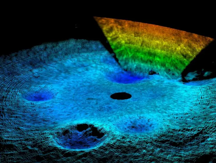 Bridge Pier (Single Scan Result)
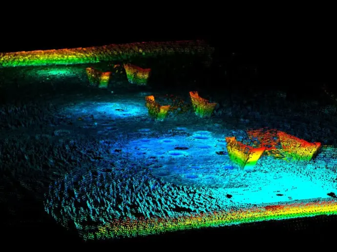 Pond Scenario (Point Cloud Mosaic After 4 Scans)
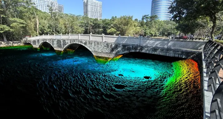 Pond Scenario (Optical Image Fusion)
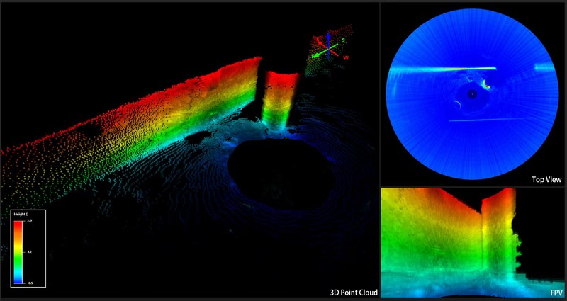 Multi-Dimensional Display Simultaneous Presentation of Point Cloud, 2D Top View and First-Person View
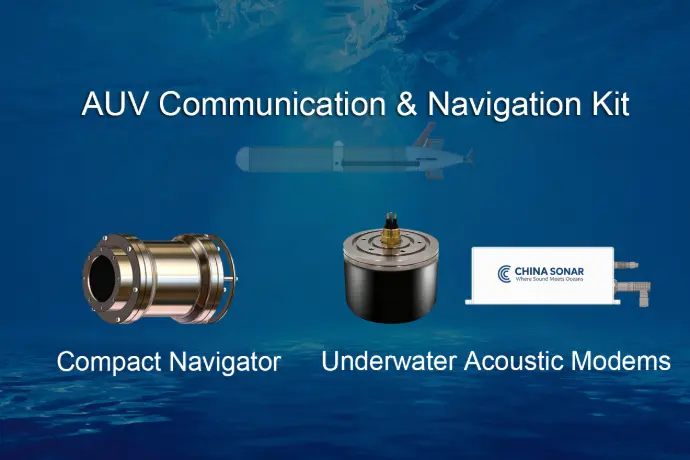
AUV Communication & Navigation Kit
Compact Navigator & Underwater Acoustic Modem
Designed for Autonomous Underwater Vehicles (AUVs), the AUV Communication & Navigation Kit delivers high-precision navigation and reliable underwater communication in a unified solution.
- NAVS-3000 Compact Navigator — Provides INS-based positioning, DVL velocity measurements, and depth data for precise real-time navigation.
-
UAC-08160X-OEM Underwater Acoustic Modem — Ensures stable, long-range underwater communication across multiple frequency bands.